
Granada Geopark
The Granada Geopark extends over an exceptional territory in the eastern part of Andalusia. The geology of the region has shaped the life and culture of its inhabitants from prehistoric times to our own day. Geology, geomorphology, archaeology and cultural legacy are closely connected in one of the territories where the oldest human remains and ancestral traditions in the European continent are found.
The territory of the Granada Geopark, with 4,722 km2 and 47 municipalities belonging to the districts of Guadix, Baza, Huéscar and Montes, includes the current river valleys generated during the Quaternary in the north of the province of Granada, as well as much of the Guadix-Baza basin and part of the mountains that delimit it. This territory has traditionally been known, from a geographical point of view, as the depressions or hoyas of Guadix and Baza. Its unique geological features supplement elements not included in other UNESCO Global Geoparks.
Since the UNESCO Global Geopark declaration was obtained (on 10 July 2020), through the International Geoscience and Geoparks programme, this territory – and especially its people – have had a unique opportunity to mitigate the constant depopulation process to which it is subject, as well as to raise public awareness of the importance of the natural, cultural and ethnographic heritage, all with a responsible attitude to the environment.
Geological history


Lands of exceptional beauty
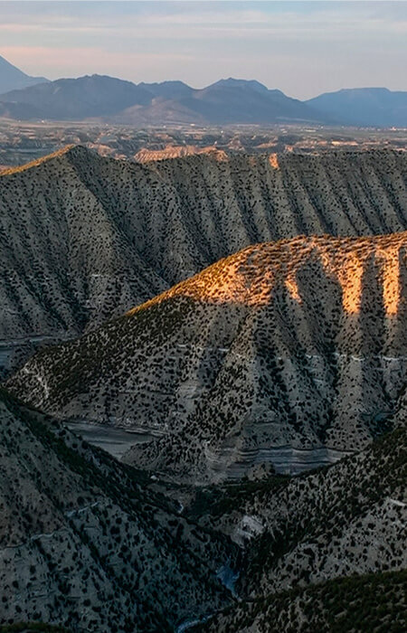
The Granada Geopark is located in the central sector of the Baetic System surrounded by some of the highest mountains in the Iberian Peninsula (Prebaetic System and Sierra de la Sagra [2,381 m], Sierra Mágina [2,187 m], Sierra de Arana-Huétor [1,940 m], Sierra Nevada [3,484 m], Sierra de Baza-Filabres [2,271 m], Sierra de las Estancias-Cúllar [1,471 m], Sierra de Orce-María [1,612 m]). All these mountains form a depression which represents most of the Geopark’s territory and has traditionally been subdivided into a western half (the Hoya de Guadix [Guadix depression]) and an eastern half (the Hoya de Baza [Baza depression]), though they actually form a single intramontane depression.
The connection between these mountains and the depression is articulated through a glacis (plain) with a very gentle slope and altitudes of between 1,150 m at the edge of the depression and 900 within it, where it is still preserved.
Between 900 m and 550 m above sea level the most remarkable landscapes in the area of the Geopark are found, formed by the various channels that drain the depression cutting into the glacis. This hydrographic network forms an arid and very uneven landscape, of which the outstanding feature is the gullies or badlands, including canyons up to 250 m deep, and the fluvial terraces of the principal rivers, which form alluvial plains known in the region as vegas.
They are harsh lands of exceptional beauty, which preserve a significant and unique part of our geological heritage in the European continent. In the universal language of rocks, they cannot fail to enthral those who come to discover their fascinating history.
The organizations that support the Geopark are::
